MixDEM Programmer's Reference GuideComponent buildingIntroduction
Components (or nodes in graph terminology) are independent units which perform simple (or sometimes complicated) transformations on data. Each component has 0 to N inputs and 0 to N outputs through which flows data. These inputs and outputs are represented by ports - Input Ports for reading data into componet nad Output Ports for writing data out of component.
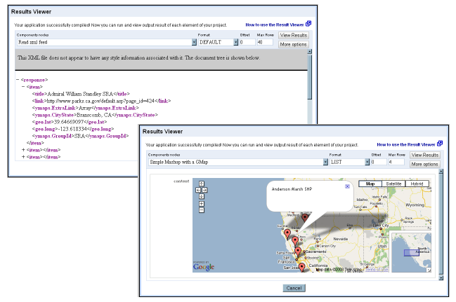
1 - A simple component based on Google Map In this section, we introduce simple component wich creating a google map and how to grab the latitude and longitude from the http://www.mapnut.com/calstatepark.xml feed, from the geo:lat and geo:long elements.. Example of an application using MAP_GOOGLE component
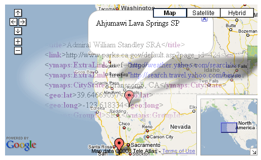
This sample application will generate an HTML page like this :<?xml version="1.0" encoding="UTF-8"?> <Graph> <!-- Define metadata --> <Metadata> <DataRecord name="geo.rss"> <DataField name="title" type="string" /> <DataField name="link" type="string" /> <DataField name="geo:lat" rename="lat" type="string" /> <DataField name="geo:long" rename="long" type="string" /> </DataRecord> </Metadata> <Element> <Node id="Read xml feed" type="XML_READER" path="rss.channel.item" url="http://www.mapnut.com/calstatepark.xml" skiprows="1" maxrows="5" /> <Node id="Simple Mashup with a GMap" type="GOOGLE_MAP" skiprows="1" maxrows="2" GMAPIKey="ABQIAAAAzr2EBOXUKnm_jVnk0OJI7xSosDVG8KKPE1-m51RBrvYughuyMxQ-i1QfUnH94QxWIa6N4U6MouMmBA" GMCenter="41.1, -121.4" GMZoom="5" GMCWidth="680px" GMCHeight="270px" GMMevent="click" GMContainer="map" GMMdataLat="@{lat}" GMMdataLong="@{long}" GMMdataHtml="@{title}" /> <Edge from="Read xml feed" to="Simple Mashup with a GMap" metadata="geo.rss" /> </Element> </Graph>  Code example with comments<!DOCTYPE html PUBLIC "-//W3C//DTD XHTML 1.0 Strict//EN" "http://www.w3.org/TR/xhtml1/DTD/xhtml1-strict.dtd"> <html xmlns="http://www.w3.org/1999/xhtml" xmlns:v="urn:schemas-microsoft-com:vml"> <head> <meta http-equiv="content-type" content="text/html; charset=utf-8"/> <title>Google Maps JavaScript API Example: Map Markers</title> <script src="http://maps.google.com/maps?file=api&v=2&key=YOUR_KEY_HERE" type="text/javascript"></script> <script type="text/javascript"> var GMapCenter = new GLatLng( 41.1, -121.4 ); var GMapZoom = 5; var GMapContainer = "map"; var GMapCGSM = true; var GMapCGMT = true; var GMapCGOM = true; var GMevent = "click"; var GMdataLat = new Array( 41.12505189 , 37.8866 ); var GMdataLong = new Array( -121.4332765, -122.32 ); var GMdataHtml = new Array( "Ahjumawi Lava Springs SP" , "Albany State Marine Reserve" ); function createGMarker( point, index, event, html, icon ) { var markerOpts; if( icon ) { var iIcon = new GIcon(baseIcon); iIcon.image = icon; markerOpts = { icon:iIcon }; } var marker = new GMarker( point, markerOpts ); GEvent.addListener( marker, event, function() { marker.openInfoWindowHtml( html ); }); return marker; } function initialize() { if ( GBrowserIsCompatible() ) { var map = new GMap2(document.getElementById( GMapContainer )); map.setCenter( GMapCenter, GMapZoom ); if( GMapCGSM ) map.addControl(new GSmallMapControl()); if( GMapCGMT ) map.addControl(new GMapTypeControl()); if( GMapCGOM ) map.addControl(new GOverviewMapControl()); for (var i = 0; i < GMdataLong.length; i++) { var point = new GLatLng( GMdataLat[i], GMdataLong[i] ); map.addOverlay( createGMarker( point, i, GMevent, GMdataHtml[i] )); } } } </script> </head> <body onload="initialize()" onunload="GUnload()"> <div id="map" style="width: 600px; height: 350px"></div> </body> </html> <?php /* +--------------------------------------------------------------------------+ | MixDEM ETL tools for Data Integration, Data Migration and Mashup edition | +--------------------------------------------------------------------------+ | Copyright ( c ) 2008 MixDEM http://sourceforge.net/projects/mixdem/ | +--------------------------------------------------------------------------+ | This program is free software; you can redistribute it and/or modify | | it under the terms of the GNU General Public License as published by | | the Free Software Foundation; either version 2 of the License, or | | ( at your option ) any later version. | | | | This program is distributed in the hope that it will be useful, | | but WITHOUT ANY WARRANTY; without even the implied warranty of | | MERCHANTABILITY or FITNESS FOR A PARTICULAR PURPOSE. See the | | GNU General Public License for more details. | | | | You should have received a copy of the GNU General Public License | | along with this program; if not, write to the Free Software | | Foundation, Inc., 59 Temple Place, Suite 330, Boston, MA 02111-1307 | | USA | +--------------------------------------------------------------------------+ | Authors: MMMed <momed@users.sourceforge.net> | +--------------------------------------------------------------------------+ */ /* +----------------------------------------------------------------------------------------------+ | $ File identity card $ | +----------------------------------------------------------------------------------------------+ | $IDFile : | | $Author : | | $DateCreation : jj-mm-aaaa --:--:-- +hhmm | | $LastModification : jj-mm-aaaa --:--:-- +hhmm | | $Contributor : | | $FileName : | | $FilePath : | +----------------------------------------------------------------------------------------------+ | $FileDescription : | +----------------------------------------------------------------------------------------------+ */ ?> <?php /************************************** HEADER GLOBAL *******************************************/ ?> <?php /********************************** LOCALS VARS & include ***************************************/ ?> <?php /***************************************** BODY *************************************************/ /** * * * @module * @category * @package * @author * @copyright * @license * @version * @link * @see * @since */ class ETL_Component_Service_Google_Google_Map extends ETL_Component { /** * string Component type */ public $type = "GOOGLE_MAP"; var $GMAPIKey = NULL; var $GMCenter = NULL; var $GMZoom = "5" ; var $GMContainer = "map"; var $GMCtrlGSM = "TRUE"; var $GMCtrlGMT = "TRUE"; var $GMCtrlGOM = "TRUE"; var $GMMevent = "click"; var $GMMIcon = NULL; var $GMMdataLat = NULL; var $GMMdataLong = NULL; var $GMMdataHtml = NULL; var $GMCWidth = "500px"; var $GMCHeight = "500px"; private $_HTML_TPL = NULL; var $skiprows = 0 ; var $maxrows = 0 ; /** * This method is called prior to starting component. * Any allocation and checking should be done here. If anything goes wrong, it * should throw throwException. * * @access public * @return boolean * * @see * @link */ function init( $options = NULL ) { GLOBAL $__L; GLOBAL $__E; $__L->info( "ETL::ETL_Component_Service_Google_Google_Map::init(" . print_r( $options, TRUE ) . ")" ); $this->skiprows = @( int ) $options["skiprows"]; $this->maxrows = @( int ) $options["maxrows"]; # check skiprows & maxrows if ( $this->skiprows < 0 ) : $this->getSuper( )->setStatus( "ERROR" ); $__E->throwException( $__E->ERROR_SKIPROWS_NEGATIVE, ", you given " . $this->skiprows . ' in [' . $this->getSuper( )->getId() . ']' ); endif; if ( $this->maxrows < 0 ) : $this->getSuper( )->setStatus( "ERROR" ); $__E->throwException( $__E->ERROR_MAXROWS_NEGATIVE, ", you given " . $this->maxrows . ' in [' . $this->getSuper( )->getId() . ']' ); endif; if( isset ( $options["GMAPIKey"] ) ) $this->GMAPIKey = @ $options["GMAPIKey"]; if( isset ( $options["GMCenter"] ) ) $this->GMCenter = @ $options["GMCenter"]; if( isset ( $options["GMZoom"] ) ) $this->GMZoom = @ $options["GMZoom"]; if( isset ( $options["GMContainer"] ) ) $this->GMContainer = @ $options["GMContainer"]; if( isset ( $options["GMCtrlGSM"] ) ) $this->GMCtrlGSM = @ $options["GMCtrlGSM"]; if( isset ( $options["GMCtrlGMT"] ) ) $this->GMCtrlGMT = @ $options["GMCtrlGMT"]; if( isset ( $options["GMCtrlGOM"] ) ) $this->GMCtrlGOM = @ $options["GMCtrlGOM"]; if( isset ( $options["GMMevent"] ) ) $this->GMMevent = @ $options["GMMevent"]; if( isset ( $options["GMMIcon"] ) ) $this->GMMIcon = @ $options["GMMIcon"]; if( isset ( $options["GMMdataLat"] ) ) $this->GMMdataLat = @ $options["GMMdataLat"]; if( isset ( $options["GMMdataLong"] ) ) $this->GMMdataLong = @ $options["GMMdataLong"]; if( isset ( $options["GMMdataHtml"] ) ) $this->GMMdataHtml = @ $options["GMMdataHtml"]; if( isset ( $options["GMCWidth"] ) ) $this->GMCWidth = @ $options["GMCWidth"]; if( isset ( $options["GMCHeight"] ) ) $this->GMCHeight = @ $options["GMCHeight"]; if ( empty( $this->GMAPIKey ) ) : $this->getSuper()->setStatus( "ERROR" ); $__E->throwException( $__E->ETL_COMPONENT_SERVICE_GOOGLE_GOOGLE_MAP_EMPTY_APIKEY, ' in [' . $this->getSuper( )->getId() . ']' ); endif; $this->_HTML_TPL = " <!DOCTYPE html PUBLIC \"-//W3C//DTD XHTML 1.0 Strict//EN\" \n" . " \"http://www.w3.org/TR/xhtml1/DTD/xhtml1-strict.dtd\"> \n" . " <html xmlns=\"http://www.w3.org/1999/xhtml\" xmlns:v=\"urn:schemas-microsoft-com:vml\"> \n" . " <head> \n" . " <meta http-equiv=\"content-type\" content=\"text/html; charset=utf-8\"/> \n" . " <title>Google Maps</title> \n" . " <script src=\"http://maps.google.com/maps?file=api&v=2&key=" . $this->GMAPIKey . "\"" . " type=\"text/javascript\"></script> \n" . " <script type=\"text/javascript\"> \n" . " // Google Map Center \n" . " var GMCenter = new GLatLng( " . $this->GMCenter . " ); \n" . " \n" . " // Google Map Zoom \n" . " var GMZoom = " . $this->GMZoom . "; \n" . " \n" . " // Google Map Container HTML Element \n" . " var GMContainer = \"" . $this->GMContainer . "\"; \n" . " \n" . " // Google Map Control GSmallMapControl \n" . " var GMCtrlGSM = true; \n" . " \n" . " // Google Map Control GMapTypeControl \n" . " var GMCtrlGMT = true; \n" . " \n" . " // Google Map Control GOverviewMapControl \n" . " var GMCtrlGOM = true; \n" . " \n" . " // Google Map Marker event handler \n" . " var GMMevent = \"" . $this->GMMevent . "\"; \n" . " \n" . " // Google Map Marker icon URL \n" . " var GMMIcon = " . $this->GMMIcon . "; \n" . " \n" . " // Google Map Marker Lat \n" . " var GMMdataLat = new Array( {GMMdataLat} ); \n" . " \n" . " // Google Map Marker Long \n" . " var GMMdataLong = new Array( {GMMdataLong} ); \n" . " \n" . " // Google Map Marker InfoWindowHtml content \n" . " var GMMdataHtml = new Array( {GMMdataHtml} ); \n" . " \n" . " function createGMarker( point, index, event, html, icon ) { \n" . " var markerOpts; \n" . " \n" . " if( icon ) { \n" . " var iIcon = new GIcon(baseIcon); \n" . " iIcon.image = icon; \n" . " markerOpts = { icon:iIcon }; \n" . " } \n" . " \n" . " var marker = new GMarker( point, markerOpts ); \n" . " \n" . " GEvent.addListener( marker, event, function() { \n" . " marker.openInfoWindowHtml( html ); \n" . " }); \n" . " \n" . " return marker; \n" . " } \n" . " \n" . " function initialize() { \n" . " if ( GBrowserIsCompatible() ) { \n" . " var map = new GMap2(document.getElementById( GMContainer )); \n" . " \n" . " map.setCenter( GMCenter, GMZoom ); \n" . " \n" . " if( GMCtrlGSM ) map.addControl(new GSmallMapControl()); \n" . " if( GMCtrlGMT ) map.addControl(new GMapTypeControl()); \n" . " if( GMCtrlGOM ) map.addControl(new GOverviewMapControl()); \n" . " \n" . " for (var i = 0; i < GMMdataLat.length; i++) { \n" . " var point = new GLatLng( GMMdataLat[i], GMMdataLong[i] ); \n" . " map.addOverlay( createGMarker(point, i, GMMevent, GMMdataHtml[i])); \n" . " } \n" . " } \n" . " } \n" . " </script> \n" . " </head> \n" . " <body onload=\"initialize()\" onunload=\"GUnload()\"> \n" . " <div id=\"map\" style=" . "\"width: " . $this->GMCWidth . "; height: " . $this->GMCHeight . "\"></div> \n" . " </body> \n" . " </html> \n"; return TRUE; } /** * This is a main processing method of component. * By implementing run() method, we define what is the thread going to do. * After the graph is initialized (by colling init() methods of all registered * components), for every component in graph, there is a thread started and it * executes run() method. * * @access public * @return boolean * * @see * @link */ function run( ) { GLOBAL $__L; GLOBAL $__E; GLOBAL $__A; $__L->info( "ETL::ETL_Component_Service_Google_Google_Map::run( )" ); $pattern = "/\@{(.*)}/"; preg_match( $pattern, $this->GMMdataLat , $matchesGMMdataLat ); if( count( $matchesGMMdataLat ) ): $matchesGMMdataLat = $matchesGMMdataLat[1]; else: $matchesGMMdataLat = NULL; endif; preg_match( $pattern, $this->GMMdataLong, $matchesGMMdataLong ); if( count( $matchesGMMdataLong ) ): $matchesGMMdataLong = $matchesGMMdataLong[1]; else: $matchesGMMdataLong = NULL; endif; preg_match( $pattern, $this->GMMdataHtml, $matchesGMMdataHtml ); if( count( $matchesGMMdataHtml ) ): $matchesGMMdataHtml = $matchesGMMdataHtml[1]; else: $matchesGMMdataHtml = NULL; endif; $_resultLat = $_resultLong = $_resultHtml = ARRAY( ); for ( $i = 0; $i < count( $this->getSuper( )->inEdges ) ; $i++ ) : $idEdge = $this->getSuper( )->inEdges[$i]; $edge = $this->getSuper( )->getSuper( )->getEdge( $idEdge ); for ( $index = 0 ; $index < $edge->getRecivedRecordCounter ( ) ; $index++ ) : if( $this->skiprows && $index < $this->skiprows ) : continue; endif; if( $this->maxrows && $index > $this->maxrows ) : break; endif; $_rs = $edge->getRecord( $index ); if( $matchesGMMdataLat ) : $_resultLat[] = $_rs[$matchesGMMdataLat]; else: $_resultLat[] = $this->GMMdataLat; endif; if( $matchesGMMdataLong ) : $_resultLong[] = htmlentities( $_rs[$matchesGMMdataLong] ); else: $_resultLong[] = htmlentities( $this->GMMdataLong ); endif; if( $matchesGMMdataHtml ) : $_resultHtml[] = '"' . $_rs[$matchesGMMdataHtml] . '"'; else: $_resultHtml[] = '"' . $this->GMMdataHtml . '"'; endif; endfor; endfor; $_result = str_replace( "{GMMdataLat}" , implode( ", ", $_resultLat ) , $this->_HTML_TPL ); $_result = str_replace( "{GMMdataLong}", implode( ", ", $_resultLong ) , $_result ); $_result = str_replace( "{GMMdataHtml}", implode( ", ", $_resultHtml ) , $_result ); $this->_HTML_TPL = $_result ; $this->getSuper( )->writeRecordBroadcast( ARRAY( "content" => $_result ) ); return TRUE; } /** * Transform $this->super->result to default node (super) output format * * @access public * @return void * * @see * @link */ function renderDEFAULT( ) { GLOBAL $__L; $__L->info( "ETL::ETL_Component_Service_Google_Google_Map::renderDEFAULT( )" ); echo $this->_HTML_TPL; return TRUE; } } ?> |